
| ||
 | ||
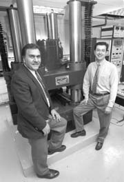 Mining researchers Ferri Hassani and Moe Momayez PHOTO: OWEN EGAN |
Helping mining firms "see" underground
|
SYLVAIN COMEAU | For the past decade, Dr. Ferri Hassani and Dr. Moe Momayez have been digging for a breakthrough in their field. Now they are mining research gold. Hassani, Webster Chair Professor of Mining Engineering, and Momayez, a research associate and lecturer in the Department of Mining and Metallurgical Engineering, have developed the proverbial better mouse trap: a superior method mining companies can use for scouting underground sites, "seeing" below the earth.
"About ten years ago, during a brainstorming session, it came to us that we could fill the mining industry's need to know just where the ore body is [at a mining site]," Hassani recalls. "The technology we decided to develop is called 'near field geophysics,' in which we are looking at depths of up to 100 metres, and which can define in much more detail what lies in the ground." "The traditional method is to draw a map of the site by drilling holes and making estimates based on the drill results," says Momayez. "They employ mathematical constructs -- guess work, really -- to try to figure out what is between bore holes. We want to eliminate the guesswork, without the need to drill many holes, which can be very expensive." Eliminating guesswork also means great leaps forward in terms of efficiency, Hassani explains. "By being able to know the location and the shape of the ore body, mining companies can design their mine much more accurately, and cost effectively. A mine is cost effective when a company is extracting eight per cent ore grade. But as mining progresses toward the edge of the deposit, the ore grade drops gradually to one or two per cent. Since the ore/waste ratio controls the survival of a mine, it is vital for a mining company to be able to concentrate their mining activities in and around ore-rich areas." To eliminate much of that uncertainty, Hassani and Momayez use a technique called Ground Probing Radar (GPR). The method involves using radar (electromagnetic) waves to create a 3-D map of the geological formation at a mining site. For the first time, radar technology is used as a tool to assist the mining engineer to probe the rock mass to "see" what lies ahead before excavation progresses. "This is essentially the same principle that airports, or the military, use to track airplanes," Momayez explains. "The difference is that we turn the antenna around, and direct the waves toward the ground. When you send waves into the air, they don't come back at you until they encounter an object. However, when you send the waves into the ground, waves bounce back constantly, off rocks, off ore, off everything in the ground. It would be as if you sent radar into the air, and the sky was full of planes." The trick is to be able to distinguish between the ore body and everything else in the ground sending signals back toward the antenna. Hassani and Momayez have developed powerful signal and image processing software to cope with the challenge. Sponsorship for this research originally came from NSERC grants, as well as the private sector: companies such as Falconbridge, Noranda, Inco, and, in recent years, Hydro- Québec. "Originally, our work was aimed at mining applications, but eventually we came to realize that it could have civil engineering applications as well," says Hassani. "There is a great demand for methods of inspecting roads, bridges and dams for flaws or cracks." The researchers are patenting a new technique, which they have dubbed MSR (Miniature Seismic Reflection) through McGill's Office of Technology Transfer. The technique uses seismic or sound waves instead of radar. "In addition to locating flaws, this technique (MSR) also gives us a way of measuring the quality of the material," Momayez adds. "If the concrete is degrading, it will have a different set of properties than if it is new. That tells us a lot about the integrity of a structure -- whether it will hold up or eventually crumble." They have already obtained numerous contracts, with several mining companies as well as with Hydro-Québec, to put the work into practice. Hydro-Québec is using the McGill duo's techniques for inspecting dams to detect any cracks, so that they can be repaired long before they become a problem. For mining companies, such as Inco, Falconbridge and Barrick Gold, they have demonstrated safety-oriented applications in addition to detecting the location of ore bodies. "In one particular mine, the workers were refusing to work in a certain area because they were afraid that there were cavities underneath, which could cause cave-ins. So we did a scan, and showed them that there are no cavities. After that, they continued their work without fearing that the ground would collapse under their weight." The next stage of their research will be aimed at putting themselves out of business as consultants on such jobs. "At the moment, companies cannot use the technique without employing expert consultants -- us," says Hassani. "Our goal is to improve the software to the point that any company can use it and almost instantly obtain a map of their mining site. We hope to have a complete hardware and software package which can do that in five years." Another, more immediate, goal is to establish a centre of excellence on subsurface sensing in collaboration with Queen's University, the University of Waterloo and the University of British Columbia. The researchers recently applied to the Network of Centres of Excellence.
|
|
| |||||